Read

In honor of Father’s Day, I’m going to engage in one of my favorite past-times: $#!+posting dad jokes. 😏
If you’re a dad (or you have a dad– I guess that’d be everyone here except my immaculate conception, clones, androids and the asexual reproduction homies) please add to the ensuing and possibly annoying thread. Consider yourself warned for irony, cringe and general rando post fun & mayhem.
–Also go wish your dad a Happy Father’s Day before you forget 😜
Let’s get it started:
- I was going to get a brain transplant, but I changed my mind
- Did you hear about the guy whose whole left side was cut off? ...He's all right now...
- I've been trying to come up with a dad joke about momentum . . . but I just can't seem to get it going.
Japan has good neighborhood streets
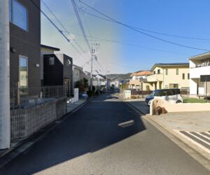
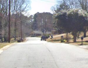
I've been telling people for years how the narrowness of the streets in Japan is probably the best traffic calming device I've ever seen and works on almost every mode of traffic from large truck down to pedestrian. In the States, we build roads way too wide for their intended use, then complain later when we see people driving on them like mini freeways. The street I lived on in Japan was about 10 meters wide; the one I live on now is about 20. (Thats 30 and 60 feet respectively for us 'Muricans)
I had to take the regular driving course to get licensed here as well; this is something different as well; if you want to drive in Japan, you spend US$3000 to go to driving school for 3-5 months. That never happens in the US, even for commercial truckers. The other thing is how the laws are enforced. Japanese traffic police are very good at their jobs, especially motorcycle and bike cops. The painted sharrows and Dutch style bike edge lanes are very recent, like in the last 5-10 years or so; what's more at work here is just a long history of Japanese traffic law being very strict especially beginning in the mid 1990's when it on-street parking was made illegal nationwide (something also not talked about by almost anyone, but is very noticeable to anyone coming to Japan.)
I'll die on this hill: Laws are only as good as their enforcement, adherence and understanding. Learning to drive, ride, and even walk as a pedestrian in Japan is something that is reinforced and understood by the vast majority and that's the main reason why you see things the way they are.
Japan still has significant progress to make in terms of car versus bike/pedestrian safety. A few years ago, a dear friend of mine was fatally struck by a car while crossing mid-block on a busy road in Nagoya. He was on his bicycle, and although I'm not fully aware of the details, the police indicated that the primary cause was his decision to cross a major road at night outside of the crosswalks, on what is known as a "stroad". Such incidents are often attributed to "user error", and it's uncertain if any design changes could prevent these types of accidents. Nonetheless, it's somewhat consoling to know that this is the only traffic fatality I've experienced in Japan, compared to six I've known in the US over a similar period of about twenty years. I lived in Nagoya for three years about 13 years ago and it's known for being the place with the most traffic safety issues per capita in Japan due in part to its wider than average boulevards and a relatively lower public transit coverage plus higher car dependence and sprawl when compared to Osaka and Tokyo metros (which is still way better than the typical American city anyway). This is Toyota and Mitsubishi's hometown after all. Even still, there are places like Sakae and Hisaya-Odori Park along with lots of underground pedestrian plazas that serve to help keep the center of town first class for pedestrians and separate from car traffic.
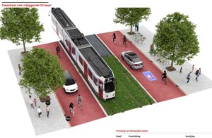
By implementing road diets to narrow streets, creating space for multiuse trails, encouraging lower speeds through design rather than solely by law, and designating residential areas as "living streets," we can enhance pedestrian safety and reduce wear and tear on vehicles. This is something that doesn't need to be done in one go; it can be done in phases as streets come up for reconstruction, can be done with just a little bit more money than said maintenance, and has been successful in the vast majority of places it has been implemented. I've been reading books like Building the Cycling City and even the Amsterdam Red Book for urban mobility to gather some of these points. I cannot stress enough how much better life in the suburbs would be if we made better use of the space we have by ceding a chunk of it away from automobiles and back to human beings.
…Now they’re just grasping at straws. We asked for something like this back in 2018 complete with a framework to provide AirBNB style housing and helping with Japanese government services like hoken, and the like. I’m sure none of the support part is included here and we all know how hard that is for anyone new to Japan.
Suddenly a new ATL transit NIMBY group has appeared! 🫢
The whole reason the Beltline even exists is because it was meant to be a transit corridor. A multiuse trail was also part of the design, so both need to be constructed.
But also, since the land developers jumped into the fray and built their car-oriented buildings off the trail, OF COURSE they want to keep it this way.
I’m sick and tired of the false notion that transit BRINGS IN undesirable effects when the exact opposite has always been true. Let’s look at their concerns and I’ll chime in with my opinions on why it’s simply not true.
-
There will be a heat island effect due to the constrained space from having up to 40 feet of ROW taken up with tracks.
That will consume almost all greenspace between the pedestrian trail and the edge of the Beltline corridor. Most existing trees and meadows will be removed to make room for the Streetcar. Less room for public art. Less room for hanging out. And a lot less room for nature.
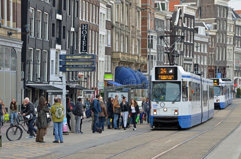
- False. The streetcar can be designed with this in mind and have grassy tracks and simple stop infrastructure. Even Houston's MetroRail tracks cross a fountain and have a small footprint. Clearly this group has never once visited an established streetcar/tram installation anywhere and seen what can be done with the ROW.
-
The Eastside Trail already is overcrowded with bikes, runners, walkers, scooters, dogs and all manner of mobility devices. It can be dangerous. We need more room for people — perhaps a wider path, or even separate lanes for “heels and wheels.”
- Yes, because the current trail setup was always intended to be TEMPORARY since the transit part needed to be installed at a later date. The final configuration with tram tracks installed will allow for all that. It's done in several other countries and even San Francisco, Portland and San Diego all have sections of their LRT systems set up in similar ways. Obviously trams will be moving along at a slower pace while on the Beltway near trail users.
-
We question spending the largest portion of Atlanta’s transit investment over the next three decades on a light-rail track that circles destinations rather than takes people to them. The Beltline already serves thousands of people daily as a last-mile, human-powered corridor. There’s little evidence of demand for long trips via rail along that corridor.
- The corridor is intended to be a light rail loop with branches that go out into places like Emory, East Atlanta, Westside Reservoir Park and Campbellton Road. Of course, some of these have been turned into BRT but the good thing about that is it can be converted at a later date to light rail. Just ask Seattle. As for demand for travel-- it hasn't been built yet, but just based on car usage alone, getting from one side of midtown to the other is a big want. Getting from the West End to East Atlanta is a big deal. There will be interfaces with MARTA subway on all sides of the Beltway and we really need a "crosstown" transfer solution that doesn't involve going through 5 Points every time. Also, points along the loop can BECOME the destination, just ask Chicago, Tokyo, Berlin, and every other city with a looping railway around their CBD.
-
Will it harm Beltline businesses?
- Are you serious? The businesses weren't even there 10 years ago; the overarching reason the developers got interested in building along the corridor in the first place is because of the TOD aspect of it-- the multi-use trail wasn't even a thing yet. So yeah, adding the rails will be what was intended in the first place and ADD TO THE ACCESSIBLILTY of the path! (my 78-year-old mom will not bike nor walk a long distance along the trail, but she'd definitely take the streetcar along the route in a hop-on-hop-off fashion.)
-
Is this really Atlanta's highest transit priority? Streetcar expansion will run through some of the city’s wealthiest and least diverse neighborhoods. In other parts of the city, residents rely heavily on transit as a necessity. They could benefit from better service.
- ALL OF IT is the highest priority. The CBD (downtown/midtown) has suffered way too long from ineffective crosstown transit options. The LRT loop aspect of the beltline is supposed to change all that. Remember, these used to do the same thing for trains what needs to be done for people without cars-- get them from once part of the CBD to the other and also facilitate a termination for inbound LRTs from other locations.
- Also fact-- MARTA heavy rail probably is too costly to build new lines off of at this point, but links to Cobb and Douglas counties could still be made via LRT and might seem even more palatable if they ran into and terminated on the Beltline. Building the infrastructure needed for this option is key.
- ALL OF IT is the highest priority. The CBD (downtown/midtown) has suffered way too long from ineffective crosstown transit options. The LRT loop aspect of the beltline is supposed to change all that. Remember, these used to do the same thing for trains what needs to be done for people without cars-- get them from once part of the CBD to the other and also facilitate a termination for inbound LRTs from other locations.
-
Are we betting on a technology of the past? Rail on the Beltline was first proposed in 1999. That was before the invention of Facebook or the iPhone. It was well before ridesharing services, e-bikes, scooter rentals, autonomous vehicles and other innovations disrupted how we get around urban areas.
- I can't believe we're conflating modern streetcars with social media evolution. YES, there is still a need for accessing the area physically first. I can't pedal all the way to the Beltline from Gwinnett. But I can take MARTA rail to Inman Park from Indian Creek (now that we have a bus that serves that station from here). I don't have a bike and even if I did, I'm not carrying it on the bus/train every time. If I want to visit my uncle in Ormewood/Grant Park I have to catch a bus or two. Once the trail opens on the south end, I guess I could walk, but it's better if there was an option that was a little faster. Streetcar to the rescue!
- And hey, who's to say that there wouldn't be a branch off this part that would serve the Flat Shoals corridor and head out to Lithonia-- that has been proposed for decades.
- I can't believe we're conflating modern streetcars with social media evolution. YES, there is still a need for accessing the area physically first. I can't pedal all the way to the Beltline from Gwinnett. But I can take MARTA rail to Inman Park from Indian Creek (now that we have a bus that serves that station from here). I don't have a bike and even if I did, I'm not carrying it on the bus/train every time. If I want to visit my uncle in Ormewood/Grant Park I have to catch a bus or two. Once the trail opens on the south end, I guess I could walk, but it's better if there was an option that was a little faster. Streetcar to the rescue!
-
The entire 22-mile loop is expected to be completed around 35 years from now at a cost of $2.5 billion. That’s probably optimistic. Where's the money gonna come from?
- We should just give up because there's no funding for the whole thing right now? That's unfortunate but also how literally everything in this country gets built. We're still waiting for the rest of MARTA to get built from the original 1974 plan. Should we just have threw that one in the trash too? You already know once something is built and used, it rapidly becomes integral, and funding will come. A full Beltline streetcar loop will be something that is rare in this nation and will attract even more development and the money that comes with it. Ask Denver about their similar bet on interurban rail and even our original bet on MARTA --that we only got after Seattle passed on the federal funding. SOME OTHER CITY will get whatever we had coming to us and we'll continue to live in a car-infested hellscape outside of The Beltline.